

Photo Credit (Forest along Each Beach Trail): Karen Noeh
About 25 years ago I was inspired to hike Vancouver Island’s West Coast Trail (ok, it’s a given that I was much younger and in far better physical condition)! I felt blessed to experience nature in such a rich and remote setting and thoroughly enjoyed the challenge of the 75km (47 mile) hike.
Apparently, that trail is now more 'populated' (8,000 hikers per year/appx 50 per day) and reservations must be made to hike it. The cost for a hiking permit is appx $140 with a reservation fee of $25.
For those seeking a lesser known wilderness trail of similar scope (no reservations or fees), you might consider Haida Gwaii’s East Beach Trail.

Photo Credit: Caroline Cournoyer-Galt
Haida Gwaii’s East Beach Trail

The East Beach Trail is a 90 km (55 mi) ‘demanding’ hike along ‘East Beach’. The route is located in Naikoon Provincial Park (a wilderness area) and is rated as being ‘moderate to difficult’.

Photo Credit: Ron Caves
Shorter hikes such as the Cape Fife Trail (10km one way - see our Jan 16, 2012 Blog http://haidagwaiitourism.blogspot.ca/2012/01/hiking-cape-fife-trail.html) and the Pesuta Shipwreck (5km one way) hike connect with the East Beach Trail and are more popular as single day hiking destinations.

Photo Credit: Karen Noeh

Photo Credit: Prlog.org
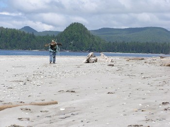
The East Beach Trail hike is for the most part, a beach walk with no firmly defined trail, however, the route is easy to follow and takes about 3-5 days to complete the trail. 
Photo Credit: Wild Isle Adventures
Note: For those looking forward to 'getting away from it all', it is rare to see other people on this hike except at the trail heads.
Please also see the BC Parks information on hiking in the Naikoon Park http://www.env.gov.bc.ca/bcparks/explore/parkpgs/naikoon/hiking.html


Photo Credit: Melinda Pick
Shipwreck! The first segment of the East Beach hike from Tlell takes hikers to the shipwreck of the Pesuta, a log-barge that ran aground in 1928.

Photo Credit: Karen Noeh
Gold in The Sand! On some parts of East Beach, patches of black sand stand out from the rest of the yellow-gray beach. These black sands are thought to contain trace amounts of gold. Local history has it that approximately 4 gold recovery operations extracted small quantities of gold from the beach at Cape in the mid-1930s.

Photo Credit: Ryan Conroy
Feral Cattle!
There have been reports over the years of ‘wild cattle’ sightings along this trail. The cattle are reportedly the descendents of free-range cattle which had been left behind by the settlers and have been described as small & shaggy and locally referred to as “hippy cows”. The sightings have become less common in recent years.

Photo Credit: Karen Noeh
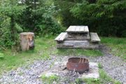
Shelter!
There are three rustic shelters along the East Beach route and are located near the mouths of Cape Ball and Oceanda Rivers approximately 2 km south of their respective river mouths, above the high tide line.

Photo Credit: Ron Caves
The Fife Point cabin has a wood stove and is located on the east beach side of the Cape Fife
trailhead.

Photo Credit: Ron Caves

Photo Credit: CanadaEH.net

Photo Credit: CanadaEH.net
At the north end of the trail, you can cut through the woods on the Cape Fife trail or continue all the way around Rose Spit (an ecological reserve).
Photo Credit: CanadaEH.net
A vehicle waiting at North Beach will be a welcome site and will transport your tired body to one of the lovely B&Bs, Cabins or hotels/motels awaiting you on Tow Hill Road or Masset...a hot bath and a meal to celebrate – memories for a lifetime…
Distances:
Tlell to Tow Hill via the Cape Fife Trail - 78 km
Tlell to Tow Hill via the base of Rose Spit - 89 km
Tlell Bridge to Tlell River outfall - 4.5 km
Tlell River outfall to Mayer River outfall - 4.5 km
Mayer River outfall to Cap Ball River - 6 km
Cape Ball River to Oeanda River 36.5 km
Oeanda River to Cape Fife trailhead - 17 km
This is a long and demanding wilderness hike along the length of East Beach requiring sufficient preparation and supplies. Please see the BC Parks web-site http://www.env.gov.bc.ca/bcparks/explore/parkpgs/naikoon/hiking.html for planning information or contact BC Parks staff at (250) 557-4390


